Sir William Chambers designed Peper Harow House in 1765, along with a complete set of ancillary buildings:-
to the north, Farnham Lodge with Lunettes
to the south-east, Eashing Lodge with a pediment,
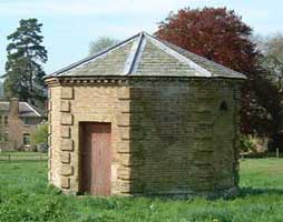
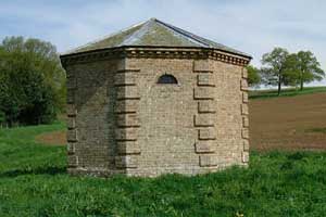
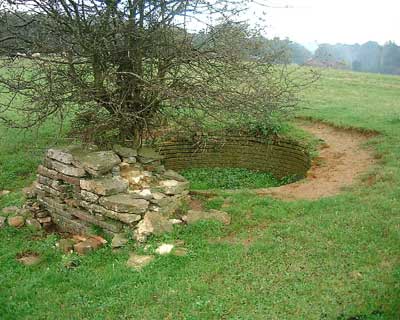
an octagonal well house near the house with rusticated quoins and tiny
lunette windows.
The big three-sided stables, now the Carriage House, according to Pevsner 'in
many ways the most impressive of the 18th Century buildings here'
Augustus Welby Pugin's influence can be seen not only in the renovation of St. Nicholas Church but also in the strange collection of buildings at Oxenford grange farm, across the River Wey.
Once the principal entrance to Peper Harow Park, they include a magnificent barn and gatehouse, thought by Pevsner to be 'among Pugin's best buildings'.
The buildings of Oxenford Grange form a fantasy of medieval architecture, a picturesque set-piece complete with weeping willow and pond.
Nearby, and dating from an earlier era, Home Farm consists of a simple, pretty 17th Century farmhouse, tile-hung above a stone ground floor. Attached to it is an impressive collection of farm buildings, including a large courtyard of rustic buildings circa 1600 granary. Listed Grade 1, it is regarded as one of the finest vernacular buildings in the south of England.
goto to Top
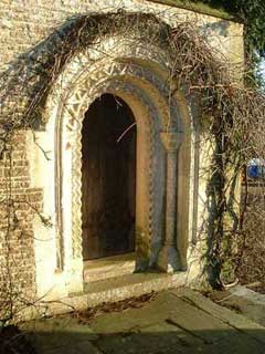
These arches are next to each other viewed from the South West outside the church wall.
Info to follow.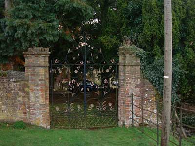
The publication the 'Heritage Features of Waverley' made a mention of a pair of ornate gilded wrought-iron gates of 19th Century origin, which stood at the entrance to a carriage drive into the park. These gates had been removed illegally as the estate was sold off into residential plots in 1995. By a stroke of luck, they were spotted for sale some months later in a local architectural salvage yard and purchased back by the families who had just moved into the estate. After renovation, the gates were reinstalled in their original location by a working party of residents, followed by a celebration liberation and much merriment. In recognition of their community spirit, Waverly Borough Council bestowed an Environmental Award on the residents of Peper Harow in 1996.
This small building has recently been restored by volunteers from S.P.A.B. 'The Society for the Protection of Ancient Buildings'
On a plan dated 1947 it is marked as a Well House and being uphill from the mansion may have been the water source well.
It has 3 small lunette windows and its door is facing north, inside there is no floor, just a drop of about a foot to the water, which is about 18 inches deep, it is clean and clear, but is not visably moving.
This was probably a water storage for the mansion, and was probably piped there before the advent of mains water.
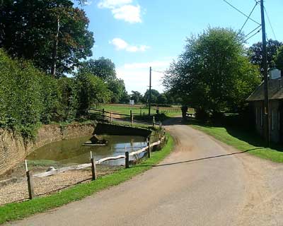
This pond is next to the Carriage House and opposite St Nicholas Church Lych Gate.
Its water feed is from the road and from the car park behind the farmyard.
It has a slipway from the road where once carriages would have been wheeled down the slipway to be washed.
The runoff from this pond goes under the road and then goes into a brick culvert about 18 inches high and about a foot wide, it then goes under the Carriage House courtyard and then into the garden of Dairy Cottage where it turns slightly east and goes off in the direction of the Bath House, whether it gets there is doutfull, as is likely that it may have been damaged when the deep sewage drain system was installed in the 1950's.
The Stew pond is half way along the southern border of the lawn in front of Park Avenue, and is fed from water off the back drive by the Tulip Gates and goes into the river by the Gun emplacement near the new weir.
goto to Top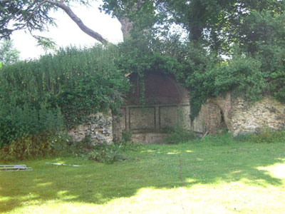
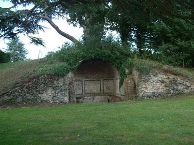
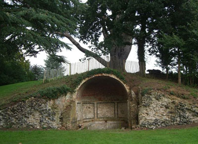
The Bath House is an enchanting red brick folly with a domed roof.
It has a natural spring, and the water runs all year round at about a
gallon a minuite.
It is located at OS ref: SU 9345E 4375N
It is south facing in a bank with a Cedar of Lebanon sheltering it from the
north, and the river Wey about 30 meters to the south west.
A working party of volunteers have been giving this folly a clean out and
have found that the bottom seems to be smooth, probably cement.
The vegetation has been cut back and the dead trees in the surrounding area removed.
During the investigation, remenants of small pebbles were found along the top
edge of the flint clading has the which would have lined the whole inside of
the dome, giving it a grotto like feel.
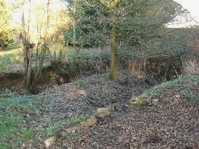
The water flow seems to come in from the left under the walkway and is supposed
to flow along a sealed channel before coming up at the far end and flowing
around open channels on both sides to the entrance.
The walls that used to hold in the water have long since collapsed but we can
tell were we think the steps down into the water would have been, we have not
yet found any drain.
goto to Top
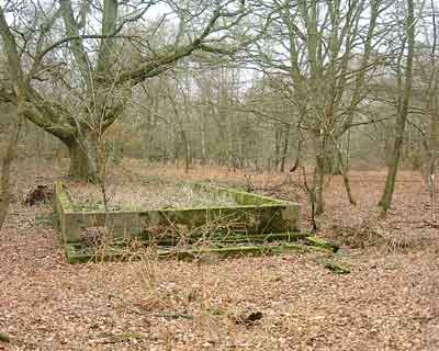
The Boat House was probably built at the same time as the mansion as a home for pleasure boats of some sort!.
The foundations and walls up to a foot above ground are still evident today but the wood boat house has long since rotted away.
It would make a nice little restoration project to dig out the silt and make an off-river mooring place for a couple of punts !.
Map Ref SU 9345E/4400N
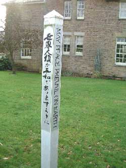
The Ley Line post is on the North lawn of Laundry Cottage which has the inscription on 3 sides 'May Peace Prevail On Earth' and on the fourth side an inscription in Japanese which may say the same thing. A delegation of Japanese visited this spot a few years ago and planted this post to mark where 3 Ley lines cross.
This may explain why this site has been inhabited since pre-historic times, it was always known as a place of healing and power.
This Ley Line just happens by chance, to be exactly on our modern metric British National Grid latitude of SU 4400N.
One particular ley centre (the term usually used for a crossing-point of leys) in this area is at the campus of the University of Surrey at Stag Hill, Guildford. There is no known prehistoric site on the hill, despite its suggestive name, and the site of the crossing-point is unmarked today, though one of its leys goes through the nearby Cathedral of the Holy Spirit, the only cathedral to be built on a new site (as far as we know!) in modern times. At least four leys cross here, one of which has been investigated by our local earth mysteries group.
This particular alignment comes from St. Mary's Church, Byfleet, a thirteenth-century building with later additions, and which a number of people have said feels very powerful, some earth energy experiments have been carried out some years ago. But perhaps the most interesting thing about it is something visible on a drawing of the church made over a hundred years ago, which is no longer there. It is what appears to be a large mound against the side of the church, carrying a staircase to a private gallery. Many churches have external staircases but normally a mound is not necessary - unless perhaps it was an ancient mound there before the church was built?
Going approximately southward it then goes through Wisley Church, whose dedication is not known. This beautiful church is entirely Norman, and has a mysterious stone in its porch, said by some to be a meteorite but more likely a sarsen stone. The path leading to the church is on the ley, and can clearly be seen to be pointing towards the stone. In the other direction the tower and small spire of Byfleet Church is just visible on the horizon.
The ley next passes through Newark Priory ruins - an Augustinian house of the twelfth century. It then goes through a cross-roads and a striking hilltop clump of Scots pines before reaching the Stag Hill centre, then going on to Shackleford and Peper Harow Churches.
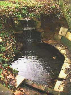
This little pond is fed by a fresh water spring, and was created by the
owner to make a romantic folly with the free water supply.
Frogs have been seen in the source spring in the summer months,
this is a good sign that the water is pure.
The flow is about two gallons a minute, and I have tasted it without any
ill effects.
The two stage water-fall took some adjusting to get the flow effect
but now looks like its been there for ages.
The water temperature is a constant 8 degrees Celcius because it comes from
deep underground, and in freezing winter months gives off a little steam.
The water is about two feet deep, enough for a dip, but only for a few
seconds I can assure you.
The finishing touches will be to build a dry stone wall to support the
surrounding banks and do some planting.
An old map from the auction of 1944 shows an Ice House in a clump of trees in the field due east of the mansion, and to the south of the cricket pavillion, at approximatley map Ref: SU 9380E 4394N
Usally situated near a spring with pond, so that the ice can be cut from the pond when frozen in winter, and often stored underground packed in straw to last to summer when its actually needed.
This Lime Kiln, is in a Norney Farm field on the brow of a hill with a thorn tree growing out of it, its at OS ref: SU 9408E 4437N
This Lime Kiln used to have a plaque set in the stonework with its date of 1708 but it is missing now.
In those days, they would have brought the chalk from The Hogs Back, the kiln, which is circular in plan and open at the top, would have the space at the bottom crammed with furze faggots, then they would build up the inside in the form of a rough arch, with the smaller pieces of chalk filled in on top.
A certain amount of burning converted the chalk into lime for fertilizer.
There is much bigger one of these in Shackleford Heath about 20 yards up Peper Harow Lane from the Elstead road junction.
From 1943 - 1945 the Canadian Ordanance Corps had their Headquarters
here at Peper Harow House, a large part of the planning for the Dieppe raid
and the Normandy invasion was carried out here.
There is what I suspect by its size and shape may have been a Tank servicing concrete base in Shackleford Heath, it has a runoff and a ditch where the mud etc. may have been washed to.
Whilst there were here they built some defensive fortifications in the form
of the Pill boxes and Gun emplacements that remain today.
From the air the field to the north of the mansion has a large X across
the corners of the field, it can only be seen from the air after a period
of dry weather.
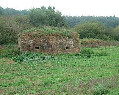
Gun emplacements, with wide openings for heavy machine guns or small artillery, these formed the part of the GHQ Line B defences for the expected invaision in 1940.
There are Gun postions at: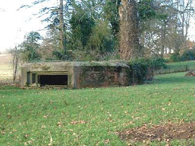
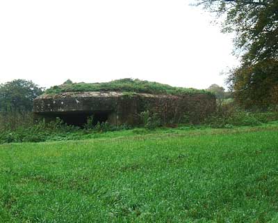
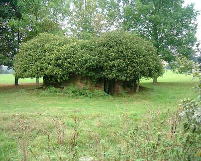
There are several Pill boxes guarding the estate at strategic positions
all with several rifle size gun ports.
There are Pillboxes at:
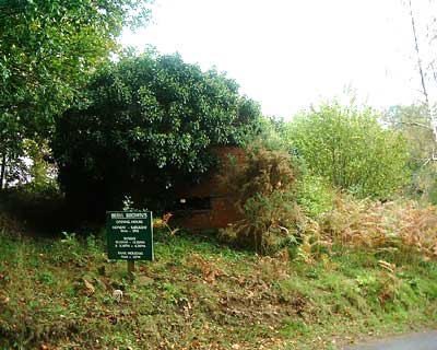
1: At OS SU926442 off Elstead Road by entrance to Beryl Browns Kennels.
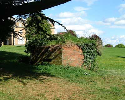
2: At OS SU935439 In the south park by the very big Cedar tree.
3: At OS SU937436 by the west cattle grid on the front drive.
4: At OS SU941435 in the field south of the front drive near the East cattle grid.
There are more of these;
At Upper Eashing, OS SU946443 about 200yds north up the footpath that goes
past Greenways Stables.
At Somerset Bridge there are a cluster of three of both types, just west of
the bridge on both sides of the river.
For more information on these, see the PillBox Study Group at
www.pillbox-study-group.org.uk/
and look in the Surrey section.